"Heatwave" forecast for Western Isles
30 June 2015
The Met Office forecasts a warm period for the Western Isles up to the weekend.
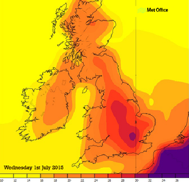
Temperatures expected to be at their highest on Wednesday afternoon.
Stornoway could sizzle with the mercury rising up to 22°C.
Uist and Barra and will see temperatures nudging the twenties.
A band of hotter weather across the UK will stop mid-
The "heatwave" will only last a day or two, with temperatures dropping by Thursday.
However, it should remain warm for the rest of the week, although it may be cloudy and raining at times with the risk of mist and possibly a thunderstorm.
It will not be as hot as the other side of the Minch with Ullapool and Oban set to
hit the mid-
Glasgow and Edinburgh and the central belt are liable to experience thunderstorm downpours on Wednesday evening.
Southeast and central England could possibly reach up to 35 °C.
The heat builds up on Tuesday as a tropical continental airmass from mainland Europe begins to dominate our weather.
Temperatures across Iberia reached 43.7 °C at Cordoba yesterday and are expected to continue to reach the low 40s Celsius here and in southern France with northern France seeing temperatures into the mid to high 30s Celsius.
Laura Paterson, deputy chief meteorologist at the Met Office, said: "Both Tuesday and Wednesday nights are expected to be warm and humid temperatures remaining in the high teens in many places, possibly low 20s Celsius in parts of southeast England.
"The very warm air means there is a risk of us seeing thunderstorms on Wednesday or Thursday but the exact timing and location of those storms, if they happen, is uncertain at the moment."