One of Europe’s rarest habitats has been mapped for the first time in Scotland by Scottish Natural Heritage (SNH).
Scotland and Ireland are the only two countries in the world that have the unique
shell-
SNH is leading a multi-
The project is a major contribution to the Scottish Government’s 2020 Challenge for Biodiversity and, together with the UK SeaMap, will in time provide a complete picture of all of Scotland’s habitats.
The new machair map we now know that there are more than 13,000 hectares of this special habitat on our coasts, mainly in the Outer Hebrides, Tiree and Coll, with smaller amounts in the Northern Isles and the west coast mainland.
The habitat is so rare because it requires a specific combination of features, including
low-
However, most crucially, machair needs the influence of people and grazing animals,
and it is found where strong on-
Machairs are suited to traditional crofting practices and for more than a thousand years have been managed using seasonal grazing, rotational cultivation without herbicides and using only natural fertilisers such as seaweed.
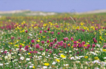
Machair is notable for its rich diversity of wild flowers and other plant species, including several uncommon orchids. This richness of plants encourages a wide variety of invertebrates, which in turn attracts birds to feed and breed. Machair grasslands, for example, are the most important UK habitat for rare species such as corncrake and corn bunting.
Professor Stewart Angus, SNH coastal ecologist, said: “Machair can be so spectacular in summer, with swathes of coloured wild flowers that change as the season progresses. On a warm summer day, with a vivid blue sea and dazzling beach sand, some of us feel there are few better places to be.
“Machair is a constantly changing habitat, so the map represents a ‘snapshot’ in
time. Accepting such limitations, this map is an invaluable aid to the assessment
of change on our coasts, with a time-
Machair is a very low-
Machair sandy coastal grasslands mapped
3 December 2016