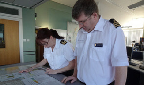
Stornoway coastguards Carol Collins and Jamie Ralston study weather warning printouts, tide reports and flood warnings to assess potential hazards in advance of the violent storm set to hit the north of Scotland overnight from Thursday into Friday.
Winds are set to increase to hurricane force 12 in the early hours of Friday said the Met Office.
Will Lang, Chief Meteorologist at the Met Office, said: "The winds will be at their strongest through the early hours of Friday and this brings the potential for disruption across Scotland, but there is a chance that strong, gusty winds could persist into the early part of the morning rush hour as well.
"We'd advise anyone planning to travel during the early part of the morning and into the early rush hour to be prepared for some transport disruption and check traffic and travel conditions before heading out to ensure you can make your journey safely."
Winds will rapidly subside through the later part of the morning, leading to a spell of quieter and very mild conditions through Friday before winds start to pick up again.
The second storm is passing further to the north, away from the UK, but is still
likely to bring gusts of 60-
Hurricane force winds warning
8 January 2015