Amber weather warnings have been issued with Storm Éowyn forecast to bring disruptive winds as well as heavy rain and some snow to the Western Isles on Friday.
Storm Éowyn risks widespread disruption on Friday and into early Saturday.
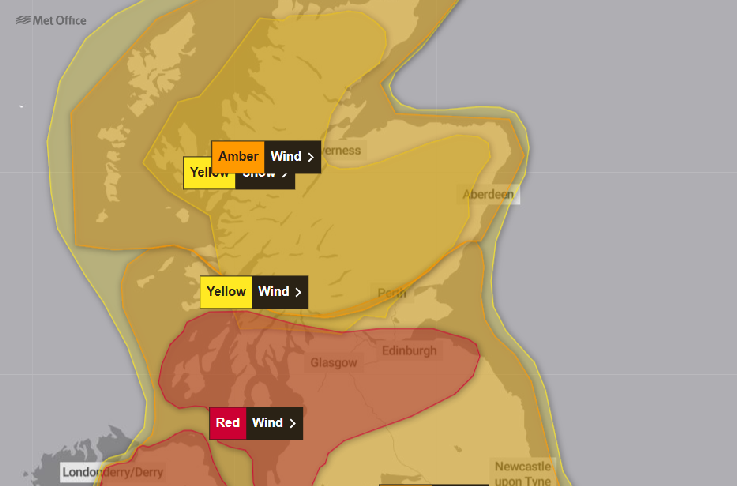
An amber warning for fierce winds covers the Hebrides and north of Scotland from lunchtime tomorrow (Friday) until 6am Saturday. A similar warning for the rest of Scotland commences earlier in the day.
A rare red warning has been issued for Central belt including Glasgow and Edinburgh areas as well as parts of Argyll which are in line to experience the worst of the storm.
Storm Éowyn will move across the northwest of Scotland on Friday, clearing to the northeast on Friday night and through Saturday morning.
This will bring a spell of very strong west to southwesterly winds, with peak gusts
of 60-70 mph fairly widely inland, 70-80 mph in some areas, and 80-90 mph along more
exposed coasts and hills - perhaps even higher in a few locations.
Winds will gradually ease from the south during Friday night and Saturday morning.
Met Office Chief Meteorologist Paul Gundersen said: “We reserve the issuing of Red Warnings for the most severe weather which represents a likely danger to life and severe disruption, and that is the case with Storm Éowyn.
“While it will be widely very windy on Friday, with additional hazards from rain
and snow, the strongest winds and most significant impacts are likely in Northern
Ireland and central and southwestern parts of Scotland within the Red Warning areas,
where winds could gust 80-90 mph quite widely for a time, and potentially up to 100
mph for exposed coasts in particular.”
After Storm Éowyn on Friday and early on Saturday, further wet and windy weather is likely on Sunday and at the start of next week, with further warnings issued.
Storm Éowyn, pronounced ‘Ay-oh-win’, will begin to influence the UK’s weather early
on Friday, with strengthening winds initially in southwestern parts of the UK with
accompanying heavy rainfall. This will quickly spread northeast to the rest of the
UK during Friday morning.
There is also a chance of snow over Northern Ireland, northern England and Scotland as the system initially bumps into cold air, however much of this will quickly change to rain as milder air moves in.
Paul Gundersen continued: “Storm Éowyn is a multi-hazard event, with snow likely
for some, rain for many and strong winds for much of the UK. As a result, a number
of weather warnings have been issued, with all parts of the UK covered by one warning
at some point on Friday.
“Storm Éowyn is expected to cross Northern Ireland early on Friday morning. It will then continue northeast across the northern half of Scotland during Friday afternoon and is expected to be centred near Shetland during Friday evening.
“It’s important to note that even those away from the immediate Red Warning areas will still likely see disruptive weather, with travel plans likely to be severely impacted, as well as the possibility of power cuts for some.”
Snow and rain represent additional hazards with this event, with warnings issued.
The snow is likely to be relatively short-lived before it shifts to rain, but still
has the potential to cause disruption, with some surface water flooding a likely
hazard in some places.
Travel conditions are likely to be severely disrupted in the coming days.
Motorists are urged to prepare in advance for the journey and take extra care on the roads. If weather conditions become challenging they are advised to adjust their driving behaviour to manage the conditions as safely as possible.
Amber warning issued as Storm Éowyn set to bring violent wind speeds
23 January 2025